
Quickstart
Kite supports importing unwrapped displacement scenes from different InSAR processors:
Each processor delivers different file formats and metadata. In order to import the data into Kite, data has to be prepared. Details for each format are described in kite.scene_io.
Importing data to spool
When you have processed your InSAR data and aligned with the expected import conversions (kite.scene_io), you can use spool to import the data:
spool.¶spool --load data/my_scene-asc.grd
Inspecting a scene with spool
You can use start InSAR Scene Inspection with Spool to inspect the scene and manipulate it’s properties.
from kite import Scene
sc = Scene.import_file('unwrap_ll.grd')

# Start the GUI
sc.spool()
spool can be started from command line.¶# Start spool and import a displacement scene data
spool --load unwrap_ll.grd
# Or load from Kite format
spool my_scene.yml
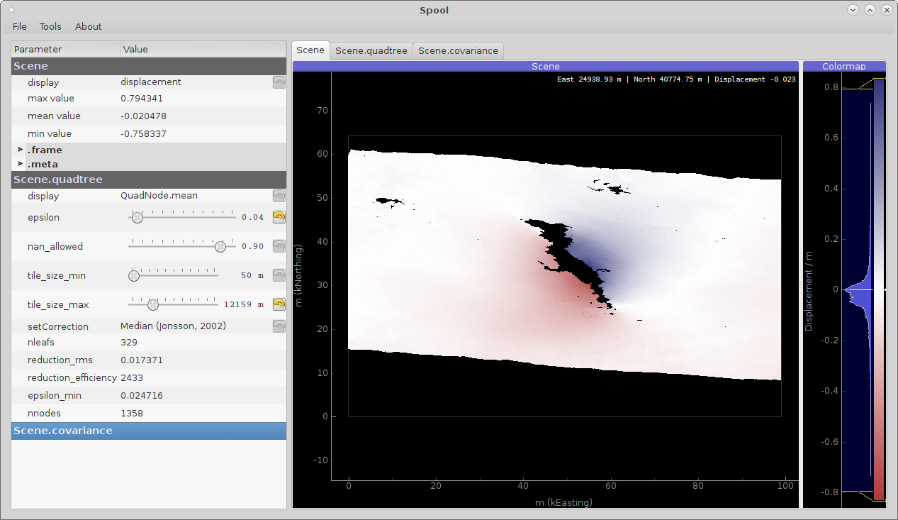
Figure 1: Manipulating unwrapped InSAR surface displacement data in Spool, Kite’s GUI.
Scripted data import
We will start with importing a scene from GMT5SAR using a Python script:
.grd file.¶from kite import Scene
# We import a unwrapped interferogram scene.
# The format shall be detected automatically
# in this case processed a GMTSAR5
sc = Scene.import_data('unwrap_ll.grd')
# Open spool
sc.spool()
Scripted scene setup
Initialisation of a custom scene through a Python script. Here we will import arbitrary data and define the geographical reference frame manually.
from kite import Scene

sc = Scene()
sc.displacement = num.empty((2048, 2048))

# Dummy line-of-sight vectors in radians
# Theta is the elevation angle towards satellite from horizon in radians.
sc.theta = num.full((2048, 2048), fill=num.pi/2)
# Phi, the horizontal angle towards satellite in radians, counter-clockwise from East.
sc.phi = num.full((2048, 2048), fill=num.pi/4)


# Reference the scene's frame lower left corner, always in geographical coordinates
sc.frame.llLat = 38.2095
sc.frame.llLon = 19.1256

# The pixel spacing can be either 'meter' or 'degree'
sc.frame.spacing = 'degree'
sc.frame.dN = .00005  # Latitudal pixel spacing
sc.frame.dE = .00012  # Longitudal pixel spacing

# Saving the scene
sc.save('my_scene')
Saving the scene and quadtree/covariance
The native file structure of Kite is based on NumPy binary files together with YAML configuration files, holding all meta information and configurable parameters, such as:
and
Meta.
This structure also holds the kite.Covariance.covariance_matrix, which requires a computational intensive task!
This code snippet shows how to import data from a foreign file format and saving it to kite’s native format.
from kite import Scene

# The .grd is interpreted as an GMT5SAR scene
sc = Scene.import_data('unwrap_ll.grd')

# Writes out the scene in kite's native format
sc.save('kite_scene')
kite_scene.npz
kite_scene.yml
Download and import data from ARIA (NASA)
The ARIA web service provides unwrapped Sentinel-1 data covering selected regions. The data can be explore on the website. For this example we use wget to download the ascending and descending ARIA GUNW data products from ARIA from the 2019 Ridgecrest Earthquakes.
# Ascending
wget https://aria-products.jpl.nasa.gov/search/dataset/grq_v2.0.2_s1-gunw-released/S1-GUNW-A-R-064-tops-20190710_20180703-015013-36885N_35006N-PP-9955-v2_0_2/S1-GUNW-A-R-064-tops-20190710_20180703-015013-36885N_35006N-PP-9955-v2_0_2.nc

# Descending
wget https://aria-products.jpl.nasa.gov/search/dataset/grq_v2.0.2_s1-gunw-released/S1-GUNW-D-R-071-tops-20190728_20190622-135213-36450N_34472N-PP-b4b2-v2_0_2/S1-GUNW-D-R-071-tops-20190728_20190622-135213-36450N_34472N-PP-b4b2-v2_0_2.nc
Now use the Python package ARIA-tools to extract three channels (unwrappedPhase, incidenceAngle, azimuthAngle) from the ARIA data product:
ascending and descending.¶# Extract into ascending/
ariaExtract.py -w ascending -f S1-GUNW-A-R-064-tops-20190710_20180703-015013-36885N_35006N-PP-9955-v2_0_2.nc -d download -l unwrappedPhase,incidenceAngle,azimuthAngle
# Extract into descending/
ariaExtract.py -w descending -f S1-GUNW-D-R-071-tops-20190728_20190622-135213-36450N_34472N-PP-b4b2-v2_0_2.nc -d download -l unwrappedPhase,incidenceAngle,azimuthAngle
For more information see ariaExtract.py --help and the ARIA-tools documentation.
Import ARIA GUNW data into Kite
To import the data into spool use a regular load:
spool --load ascending
Note
ARIA scenes are provided at a high resolution and calculation of the covariance matrix can take a long time!
Download and import data from COMET LiCSAR
A slim client for downloading COMET LiCSAR products is included in kite.clients. The script will download the passed unwrapped LiCSAR data and necessary LOS GeoTIFFs into the current directory.
This example will download data from the 2017 Iran–Iraq earthquake (M 7.3) from the COMET LiCSAR Portal:
python3 -m kite.clients http://gws-access.ceda.ac.uk/public/nceo_geohazards/LiCSAR_products/6/006D_05509_131313/products/20171107_20171201/20171107_20171201.geo.unw.tif .
Now just load the scene into Kite or spool.
spool --load 20171107_20171201.geo.unw.tif
Converting StaMPS velocities to a Kite scene
The CLI tool stamps2kite loads PS velocities from a StaMPS project (i.e. processed mean velocity data through ps_plot(..., -1);), and grids the data into mean velocity bins. The LOS velocities will be converted into a Kite scene.
StaMPS’ data has to be fully processed through and may stem from the master project or from one of the processed small baseline pairs. The required files are:
ps2.matMeta information and geographical coordinates.parms.matMeta information about the scene (heading, etc.).ps_plot*.matProcessed and corrected LOS velocities.mv2.matMean velocity’s standard deviation.look_angle.1.inLook angles for the scene.width.txtWidth dimensions of the interferogram andlen.txtlength.
stamps2kite stamps_project/ --resolution 800 800 --save my_kite_scene
For more information on the util, see the --help.